Benefits of Drone Photography in Real Estate
In the competitive Miami real estate market, showcasing properties through innovative and captivating visuals is essential to attract potential buyers and stand out from the competition. Drone photography offers a distinct advantage by providing stunning aerial views that traditional photography cannot achieve. These high-quality images highlight a property’s exterior features, landscaping, proximity to amenities, and surrounding neighborhood context with exceptional clarity and perspective. Such visuals allow prospective buyers to better understand the property’s layout and location, fostering an emotional connection even before a physical visit.
Utilizing drone technology enhances the overall appeal of property listings by delivering dynamic content that captures attention across digital platforms. Aerial footage reveals expansive outdoor spaces, showcasing features like pools, patios, gardens, and access points in a way that ground-level photos often miss. This comprehensive visual storytelling results in increased engagement, longer viewing times, and higher likelihoods of inquiries. Additionally, images captured from elevated angles can illustrate property boundaries and neighborhood dynamics, providing valuable context for buyers seeking the perfect location.
Real estate professionals who incorporate drone photography into their marketing strategies also benefit from improved brand positioning. A portfolio enriched with professional-grade aerial images demonstrates commitment to quality and innovation, cultivating greater trust among clients. Enhanced listing appeal can lead to quicker sales cycles and potentially higher property values due to elevated presentation standards. Moreover, the immersive quality of drone footage lends itself well to virtual tours and online advertising, expanding reach and attracting interest from a broader audience.
In essence, integrating drone photography into real estate marketing unlocks visual storytelling opportunities that elevate property presentations, foster buyer confidence, and accelerate the sales process. Its ability to showcase properties from a unique vantage point provides a competitive edge that modern real estate professionals can leverage to their advantage in the vibrant Miami market.
Choosing the Right Drone Equipment for Real Estate
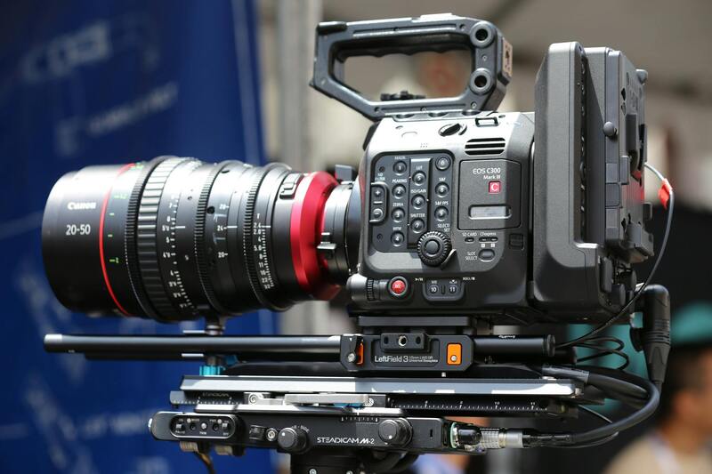
For real estate professionals aiming to leverage drone photography effectively, selecting the appropriate equipment is crucial. High-quality drone technology allows capturing sharp, detailed images with accurate color representation, enhancing the overall appeal of property listings. The ideal drone should feature a stable gimbal system, which ensures smooth, cinematic video and clear, distortion-free photographs from various angles. Additionally, flight stability is essential, especially when capturing images in challenging weather conditions or confined spaces.
Key specifications to consider include camera resolution, which ideally should be 4K or higher to produce crisp visuals suitable for large displays and print. Battery life is another vital factor, as longer flight times permit comprehensive coverage of properties without frequent interruptions. Moreover, advanced navigation systems, such as GPS waypoint control, facilitate precise positioning and automated flight paths, enabling consistent results across different shoots.
In terms of durability and ease of use, drones designed with weather-resistant features tend to perform better in various environmental conditions, maintaining image quality and safety. Compatibility with editing software, as well as features like adjustable camera angles and ultra-wide lenses, further empower real estate professionals to craft compelling visual narratives.

By investing in reliable, capable drone hardware, real estate agents can ensure their aerial imagery meets high standards and stands out in competitive markets like Miami. Coupled with proper training on equipment operation, this approach maximizes the quality and safety of drone shoots, ultimately enhancing the effectiveness of property marketing campaigns.
Best Practices for Aerial Property Photography
Achieving stunning aerial images that effectively showcase a property requires strategic planning and technical precision. First, optimal lighting conditions should be prioritized, with early mornings or late afternoons offering softer, more appealing light that enhances property features without harsh shadows. Planning the flight path in advance allows for consistent coverage and minimizes the risk of missed angles or obstructed views. Utilizing pre-determined waypoints can ensure comprehensive coverage of the property, capturing both the exterior and surrounding landscape in a cohesive manner.
Maintaining appropriate altitude is crucial; flying too high may diminish the impact of visual storytelling, while too low might not capture the full scope of the property. Typically, a height that balances detail and context—usually between 50 to 150 feet—is recommended. Additionally, camera settings such as ISO, shutter speed, and aperture should be adjusted to match lighting conditions, ensuring clear, distortion-free visuals with vibrant colors and sharp details.
Weather conditions can significantly influence image quality. Clear, calm days with minimal wind are ideal to prevent drone instability, which can lead to blurry images or unstable footage. Post-flight, reviewing images for sharpness and exposure is essential. Techniques like HDR (High Dynamic Range) can be employed to better capture both shadowed and brightly lit areas within the same frame, offering a more dynamic and balanced visual presentation.

Incorporating various perspectives, such as close-up shots of unique features and wide-angle views of the entire property, enhances the storytelling aspect of the visual presentation. Consistency in shooting angles and lighting across different listings helps to maintain professionalism and brand identity, making each property stand out in the competitive Miami market.
For real estate professionals, investing in ongoing training on drone operation and photography techniques is invaluable. Staying current with emerging technologies and best practices ensures high-quality results, delivering compelling visuals that attract buyers and accelerate sales.
Choosing the Right Drone Equipment for Real Estate
Selecting appropriate drone equipment is vital for achieving high-quality aerial imagery that accurately showcases a property's best features. When considering drones for real estate purposes, realtors should prioritize models equipped with high-resolution cameras capable of capturing detailed images and videos. Cameras that support 4K resolution or higher provide crisp visuals that highlight properties with remarkable clarity, which is essential for online listings and marketing materials.
Stability features such as gimbal stabilization are crucial for producing steady, professional-grade footage. Gimbals help eliminate unwanted vibrations and shaky movements, ensuring that each shot is smooth and visually appealing. Additionally, drones with adjustable camera angles expand creative possibilities, allowing for dynamic shots that emphasize the property’s orientation, landscaping, and architectural features.
Battery life is another important factor. Drones with longer flight times permit more comprehensive coverage of larger properties, reducing the need for frequent battery changes and ensuring thorough aerial documentation. For properties with extensive grounds, models supporting extended flight durations—typically 20-30 minutes per charge—are highly advantageous.
In addition to camera capabilities, drone flight control features like GPS-assisted stabilization, obstacle avoidance sensors, and automatic return-to-home functions contribute to safer operation and better image results. These equipment features not only safeguard the drone but also facilitate precise maneuvering in complex environments, ensuring that real estate visuals are shot from ideal angles and heights.
Investing in high-quality equipment also means considering weather resistance features. All-weather drones capable of operating in wind or light rain provide greater flexibility in scheduling shoots, ensuring that realtors can capture moments of optimal lighting and weather conditions.
Ultimately, the right drone technology elevates the quality of real estate marketing materials, translating to more engaging listings and quicker sales. When choosing equipment, realtors should evaluate their specific property types, shooting requirements, and budget constraints to select a drone that best aligns with their marketing goals and professional standards.
Best Practices for Aerial Property Photography
To maximize the impact of drone photography in real estate listings, it is essential to adhere to proven techniques that enhance visual storytelling. First, plan the shoot meticulously, considering the property's unique features and the best times of day for lighting, usually during early morning or late afternoon when natural light is softer, reducing harsh shadows and glare. This strategic timing ensures the captured images highlight the property's best qualities.
Utilize systematic flight paths to ensure comprehensive coverage of the property estate. Establishing specific angles and heights from which images are taken helps maintain consistency across visuals, creating a cohesive and professional presentation. For example, starting with a high-altitude overview to establish context, then zooming in or angling closer to reveal distinct architectural details or landscape features, adds depth to the listing visuals.
Camera settings should be optimized based on ambient lighting conditions to produce sharp, clear images. Adjust ISO, aperture, and shutter speed accordingly, and consider using RAW image formats for post-shoot editing flexibility. Proper stabilization and gimbal adjustments are crucial to prevent motion blur and ensure crisp visuals, especially when capturing video footage.
Operational safety remains paramount. Before each shot, perform a thorough site assessment to identify potential obstacles such as trees, power lines, or structures. Maintaining a safe distance and smooth maneuvering reduce the risk of accidents and protect valuable equipment. It’s also advisable to have a clear flight plan, including predefined waypoints and altitudes, to streamline the process and ensure all desired angles are captured efficiently.
Post-collection, attention to editing enhances the footage. Color correction, contrast adjustments, and stabilization can dramatically improve visual appeal. Incorporating aerial images into a broader marketing strategy with well-crafted descriptions and virtual tours establishes a compelling, high-quality listing that attracts potential buyers and facilitates faster transactions.
Integrating Drone Content into Real Estate Marketing
Effectively incorporating drone photography and videography into a broader real estate marketing strategy can significantly enhance property visibility and attract potential buyers. High-quality aerial content provides a distinctive perspective that traditional photography often cannot achieve, making listings stand out in competitive markets. When deploying drone footage across various platforms, it is essential to tailor the presentation to maximize engagement and convey the unique features of each property.
Online property listings benefit from immersive drone visuals that showcase the property's exterior, landscaping, and community surroundings. These images create a more comprehensive view, allowing prospective buyers to visualize the estate in its context, which can shorten decision-making timelines. Embedding high-resolution videos and 360-degree virtual tours with drone footage further enriches the listing, providing an interactive experience that captures the property's scale and layout effectively.
Social media platforms are powerful tools for realtors to extend their reach. Short clips or highlight reels highlighting key property attributes, neighborhood vistas, or surrounding amenities can generate engagement and shares. Consistent use of branded visuals and hashtags related to Miami real estate helps build recognition and attract regional or international audiences.
Integrating drone content into virtual tours offers potential buyers an authentic, high-fidelity view of properties from the comfort of their home. Combining ground-level walkthroughs with aerial shots delivers a comprehensive perspective, highlighting both interior details and exterior estate features. This approach enhances the overall professionalism of the marketing material, fostering greater trust and interest among prospective buyers.
Promotional materials such as brochures, email campaigns, and digital ads can also leverage drone images to emphasize unique property elements and location benefits. Well-crafted stories with compelling aerial visuals help differentiate listings in a saturated market, creating a memorable impression and encouraging faster transactions.
Cost Considerations and Choosing a Miami Drone Service
When selecting a drone service for real estate photography in Miami, understanding the cost structure and service offerings is essential. Reputable providers typically present transparent pricing policies, which may include various package options tailored to different property sizes and marketing needs. These packages can range from basic aerial shots to comprehensive aerial tours combined with ground-level photography and videography.
It’s important to evaluate what each package includes, considering factors such as flight time, number of images, video length, editing services, and turnaround times. Some providers offer customizable options, enabling realtors to craft a visual package that aligns with their specific listing requirements and marketing budgets.
Reputable drone operators in Miami often have a dedicated team of licensed pilots with extensive experience in real estate visuals. These professionals understand the nuances of capturing properties from optimal angles and lighting conditions, which directly impacts the quality of the final product. When assessing drone service providers, consider their portfolio, client testimonials, and adherence to safety standards to ensure your visuals are produced professionally and efficiently.
Pricing can vary depending on the complexity of the project, the location of the property, and the specific deliverables required. Some providers offer hourly rates, while others provide flat-rate packages for full property coverage. It is advantageous to discuss your marketing objectives upfront, enabling the drone service to recommend the most suitable package within your budget.
Additionally, working with a local Miami drone company offers the benefits of familiarity with the region’s unique real estate landscape, weather patterns, and airspace regulations. This local expertise ensures that your aerial visuals are captured at the most advantageous times, avoiding delays caused by weather or logistical issues.
In choosing a Miami drone service, prioritize providers who utilize state-of-the-art equipment with high-resolution capabilities. The investment in the latest technology results in sharper images, smoother video footage, and more dynamic virtual tours, all of which elevate a property’s market appeal. Exploring package options that include post-production editing and virtual staging may further enhance your listings, providing a polished, professional presentation that attracts more prospective buyers.
Ultimately, balancing cost with quality and service reliability ensures an effective real estate marketing strategy. Collaborating with experienced professionals who understand the nuances of aerial real estate photography will maximize your investment, delivering captivating visuals that resonate with buyers and accelerate property sales.
Future Trends in Drone Photography for Realtors
As technology continues to evolve, drone photography for realtors is poised to become even more integral to real estate marketing strategies. Emerging innovations in camera sensors, flight automation, and artificial intelligence are set to revolutionize how properties are showcased and perceived by potential buyers. Real estate professionals who stay ahead of these trends will be able to create more compelling, efficient, and engaging visual narratives that drive faster sales and higher property values.
Advancements in Drone Camera Technology
The next generation of drone cameras is expected to feature ultra-high-resolution sensors, capable of capturing stunning 8K or higher quality footage. Enhanced image stabilization and dynamic range will allow for footage that is not only sharper but also more true-to-life, providing viewers with an accurate visual representation of the property's features. This improved quality enables realtors to highlight even the smallest details of a property, from intricate architectural elements to lush landscaping, all from a captivating aerial perspective.
Automation and Increased Flight Capabilities
Automation is transforming drone flight operations, making it easier for realtors to execute complex shooting plans with minimal effort. Pre-programmed flight paths and autonomous flight modes allow for precise, repeatable shots at predetermined angles and times, ensuring consistency across multiple listings. Additionally, longer flight times and improved battery technology facilitate comprehensive coverage of larger properties or multiple sites in a single shoot, maximizing the content available for marketing campaigns.
Artificial Intelligence and Post-Production Enhancements
Artificial intelligence (AI) driven editing tools are enabling real estate marketers to automatically enhance drone footage, correcting color, stitching images seamlessly, and even generating virtual staging. AI algorithms can analyze aerial videos, identify key features, and optimize footage for maximum visual impact, reducing the time from shoot to listing. These advancements streamline workflows and deliver polished, professional visuals that captivate prospective buyers, giving listings a competitive edge in saturated markets like Miami.
Integration of Virtual and Augmented Reality
The future of drone photography intersects with virtual reality (VR) and augmented reality (AR), offering immersive experiences that transcend traditional property tours. Realtors can incorporate drone footage into VR walkthroughs, allowing potential buyers to explore a property remotely with realistic depth and perspective. Augmented reality apps can overlay additional information onto drone images, such as property details, renovation possibilities, or neighborhood insights, creating interactive marketing materials that deepen engagement and understanding.
Data Analytics and Targeted Marketing
Harnessing data derived from drone footage and analytics platforms will enable realtors to tailor marketing efforts more precisely. By understanding viewer engagement patterns with drone videos and virtual tours, agents can optimize content and distribution strategies. For example, high engagement with aerial shots of specific property features or neighborhoods can guide targeted advertising efforts, ensuring listings reach the most interested buyers efficiently. This data-driven approach maximizes marketing ROI and accelerates property sales in competitive Miami neighborhoods.