Importance of Aerial Property Photos in Real Estate
In the competitive landscape of Miami real estate, visually striking property presentations are essential for attracting serious buyers and facilitating faster sales. Aerial property photos have emerged as a pivotal element in modern real estate marketing, offering unique perspectives that ground-level shots simply cannot provide. These images enable potential buyers to gain a comprehensive understanding of a property's layout, surrounding environment, and key features from an elevated vantage point, thereby creating a compelling first impression.
High-quality aerial imagery enhances property listings by highlighting aspects such as expansive yards, waterfront access, proximity to amenities, and the overall neighborhood ambiance. For luxury estates, waterfront properties, and developments with significant outdoor spaces, aerial photos deliver a sense of scale and grandeur that captivates prospective buyers. They also provide context about neighboring properties and nearby infrastructure, which is crucial for buyers assessing the property's location and potential.
These photos serve more than merely aesthetic functions. They improve listing visibility across various platforms, including real estate portals and social media channels, leveraging the growing influence of visuals in digital marketing strategies. Well-captured aerial images help real estate professionals differentiate their listings in a crowded marketplace, attracting more interest, inquiries, and ultimately, faster transactions.
Moreover, aerial property photos support transparency and trustworthiness in the sales process. They allow buyers to verify property details independently, reducing uncertainties during negotiations. For developers and property managers, these images become valuable tools for showcasing project progress, land parcels, and development potential.
The enhanced visual appeal and detailed perspectives offered by aerial photography directly influence a property's marketability. As technological advancements continue to make aerial imaging more accessible, incorporating these images into marketing strategies has become a standard practice for successful real estate sales, especially in vibrant markets like Miami.
Types of Aerial Photography Equipment and Technologies
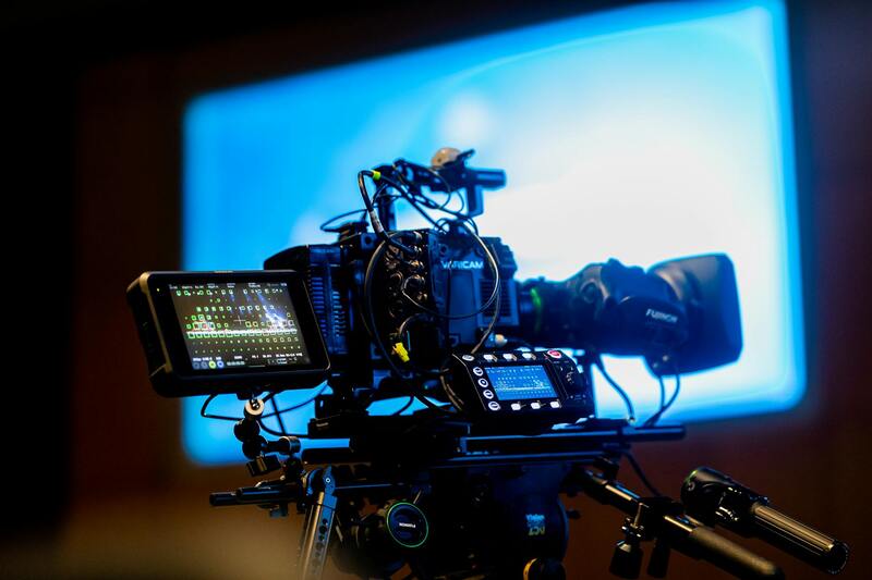
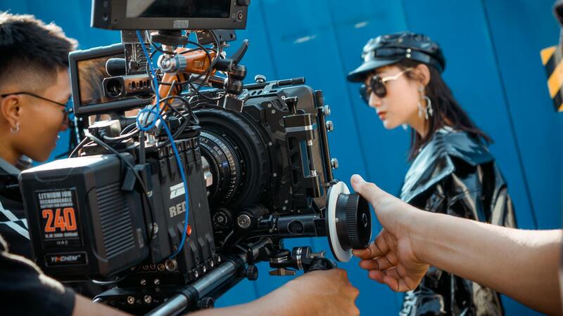
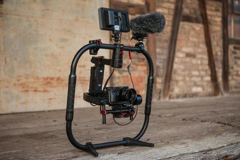
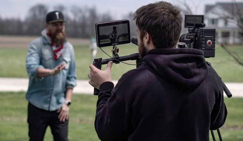
To achieve stunning aerial property photos, professionals employ a diverse array of advanced equipment and cutting-edge technologies. The foundation of high-quality imagery starts with the selection of suitable drones equipped with stabilized gimbal cameras. These drones are specifically designed to capture sharp, distortion-free images from substantial altitudes, allowing for expansive views of property layouts and surrounding environments.
Modern drone models feature GPS-assisted flight modes, automated flight paths, and obstacle avoidance sensors, ensuring precise control and safety during operation. High-resolution cameras, often capable of capturing images in 4K or higher, provide crisp details necessary for showcasing property features and landscape nuances effectively. Many professional rigs also utilize interchangeable lenses, affording flexibility in framing shots — from wide-angle perspectives that highlight entire estates to detailed close-ups of architectural elements.
Stabilization tools such as gimbals play an essential role in preventing camera shake during flight, resulting in clear, professional-grade images. Additionally, some operators incorporate thermal imaging or specialized filters to enhance certain visual aspects or capture unique views in specific conditions. These technological advancements collectively empower real estate professionals to produce compelling visual content that elevates property listings and attracts serious buyers.
Best Times and Conditions for Aerial Photography in Miami
Optimal timing and weather conditions significantly influence the quality of aerial property photos. In Miami, capturing images during the golden hours, shortly after sunrise or before sunset, offers soft, natural lighting that enhances property features and landscape details. Overcast days with diffused sunlight help reduce harsh shadows, providing even illumination across the property’s surfaces.
Clear skies contribute to vibrant blue backgrounds and clear visibility, essential for showcasing property details and surrounding infrastructure. It is advisable to avoid windy days, as strong gusts can cause drone instability and compromise image quality and safety. Consistently, calibration of camera settings to match ambient light conditions ensures optimal exposure, color accuracy, and sharpness.
Scheduling flights during favorable weather windows maximizes the potential for obtaining stunning visuals that effectively communicate a property’s appeal. This strategic approach ensures that each shoot provides the clearest, most impactful images for marketing and buyer engagement.
Legal and Safety Considerations for Aerial Photography in Miami
When engaging in aerial property photography within Miami, adherence to established operational guidelines ensures the safety of both the equipment and surrounding community. Proper planning and execution leverage modern drone technology while respecting airspace regulations to deliver high-quality visuals responsibly.
Prior to conducting aerial shoots, comprehensive pre-flight assessments are essential. These include reviewing wind conditions, ensuring unobstructed flight paths, and verifying that weather conditions are suitable to minimize risks such as drone instability or accidents. Underlying these preparations is a thorough understanding of local airspace management, which involves coordinating with relevant authorities when operating near designated zones or within restricted airspace.
Standard operational protocols emphasize maintaining visual line-of-sight with the drone at all times. This approach enhances pilot awareness and control, reducing the potential for colliding with obstacles or infringing on private properties. Additionally, establishing no-fly zones around prescribed areas, especially near airports or heliports, is crucial for safety and compliance.
During the flight, maintaining steady altitude and avoiding abrupt maneuvers are vital to preserving the quality of the footage and preventing accidents. Pilots should also inspect the drone before each flight, checking battery levels, camera functions, and propeller integrity to avoid malfunctions mid-flight.
In addition to operational safety, respecting privacy boundaries is paramount. Avoiding overflight of private residences without permission and steering clear of congregations or sensitive areas protect both the interests of property owners and the reputation of the service provider. Using designated flight routes or flight planning software can help efficiently map out optimal paths that align with safety standards.
Post-flight procedures include reviewing footage for quality, documenting the flight process, and ensuring all equipment is safely stored. Maintaining detailed records of each flight operation supports adherence to best practices and can be valuable for ongoing safety assessments.
Implementing these stages of preparation, execution, and review solidifies the professional integrity of aerial property photography projects. It guarantees that visual content is captured efficiently, safely, and in a manner that respects the legal framework guiding drone operations in Miami’s diverse urban and rural landscapes.
Official Methods for Capturing Aerial Property Photos in Miami
To ensure aerial property photos are captured effectively and ethically, it is essential to adhere to established procedures that respect privacy, safety, and regulatory standards. Professional drone operators and aerial photographers employ specific official methods that align with regional guidelines to produce high-quality imagery suitable for real estate marketing.
One fundamental approach involves meticulous flight planning. This entails using advanced mapping and flight planning software to chart precise routes that optimize coverage of the property while avoiding restricted zones such as airports or military installations. Proper planning minimizes risks and guarantees that the footage captures all critical angles and features of the property.
Furthermore, equipment calibration plays a vital role. Before each flight, operators verify the drone's camera settings—including resolution, stabilization, and framing—to ensure clarity and consistency across shots. Regular maintenance checks of the drone’s components, such as batteries, propellers, and GPS systems, are performed to avoid technical failures mid-flight, thereby safeguarding both equipment and personnel.
Adopting the right flight altitude is also critical. Flying at appropriate heights (usually between 50 and 150 feet above ground level) ensures comprehensive coverage of the property while maintaining a safe distance from structures and neighboring properties. This practice not only enhances image quality but also complies with distance regulations.
In addition to technical precision, respecting privacy and property boundaries is fundamental. This involves obtaining necessary permissions from property owners beforehand and ensuring that flight paths do not intrude into private spaces or public areas not designated for aerial imagery. Using designated overflight corridors and pre-approved routes helps streamline operations and uphold community relations.
Post-flight workflows are equally important. Reviewing the captured footage immediately after the flight allows the photographer to verify image quality and reshoot if necessary. Maintaining detailed records of each flight, including flight logs and camera settings, supports consistent results and facilitates future project planning.
Operational safety procedures—such as establishing clear communication protocols among team members, adhering to altitude restrictions, and monitoring weather conditions—further reinforce the adherence to best practices. It is also advisable to stay updated with any regional updates on drone operation policies and incorporate them into daily workflows to maintain compliance.
Implementing these official methods ensures aerial property photography conducted in Miami meets high standards for safety, quality, and respect for legal boundaries. These practices not only facilitate visually compelling content but also uphold the integrity of professional real estate marketing efforts.
Optimal Environmental Conditions for Aerial Photography in Miami
Securing high-quality aerial property photos in Miami requires careful attention to environmental factors that influence image clarity and detail. Optimal conditions include clear, cloudless skies, low wind speeds, and minimal atmospheric haze. These elements help ensure sharp, vibrant images that accurately portray property features and surroundings.
The time of day plays a crucial role in capturing visually appealing images. Early morning and late afternoon, known as the golden hours, offer soft, warm natural lighting that enhances the visual appeal of properties. During these periods, shadows are elongated, adding depth to architectural features and landscape elements.
Weather conditions must be closely monitored; flights should be scheduled during periods of stable weather to avoid issues caused by rain, fog, or gusty winds. These elements can compromise camera stability and image sharpness, leading to blurry or obscured photographs.
Understanding local weather patterns in Miami helps plan optimal shooting windows, particularly during dry seasons with predictable clear skies. Advanced weather forecasting tools and professional drone operators are instrumental in scheduling flights for maximum safety and quality.
Proper Techniques for Capturing Effective Aerial Property Photos
Achieving high-quality aerial property photos requires more than just operating a drone; it demands a strategic approach and mastery of various techniques that enhance the visual appeal and informational value of each shot. Aerial photographers should focus on several key practices to ensure every image effectively showcases the property's features and surroundings.
- Optimal Framing and Composition: Applying principles such as the rule of thirds can help position the property dynamically within the frame. Ensuring the main architectural elements or landscape features are prominently centered or balanced in the shot creates a compelling visual narrative.
- Consistent Altitude and Angles: Maintaining a steady altitude ensures uniformity across photography sessions and provides a clear perspective of the property. Experimenting with different angles—bird's eye views, oblique shots, and oblique angles—can reveal details that appeal to potential buyers and highlight the property's scale and context.
- Lighting and Shadow Management: Capturing images during the golden hours (shortly after sunrise or before sunset) allows for diffused light that accentuates textures and architectural details without harsh shadows. Adjusting drone angles slightly can help manage shadows cast by trees, structures, or natural formations, optimizing the clarity and aesthetic of each shot.
- Maintaining Image Sharpness: High-resolution imaging and stable flight paths are essential. Using gimbals and stabilization systems ensures smooth footage, while manual or automatic focus adjustments prevent blurriness, especially when zooming or framing detailed features.
- Attention to Background and Foreground Elements: Integrating natural or architectural foreground elements can add depth and context to the images. This technique provides viewers with a more immersive understanding of the property's surroundings.
In addition to technical skills, meticulous planning regarding flight paths and camera settings is crucial. Utilizing pre-flight checklists and flight planning tools helps ensure comprehensive coverage of the property, capturing multiple perspectives and elevations. This thorough approach results in a collection of images that can be used to craft compelling marketing narratives, older and newer, that resonate with prospective buyers and investors alike. Ultimately, mastering these techniques leads to aerial photos that truly stand out in the competitive Miami real estate market, combining artistry with precision to showcase each property’s unique appeal.
Understanding the Technical Aspects of Aerial Property Photography in Miami
Achieving high-quality aerial property photos hinges on a comprehensive understanding of the technical tools and methodologies employed during the shoot. This involves selecting the right hardware, optimizing camera settings, and mastering flight control techniques to ensure each image accurately represents the property while highlighting its most attractive features.
One of the foundational elements is the choice of aerial photography equipment. Drones equipped with high-resolution cameras—typically 4K or higher—are standard, as they provide crisp, detailed images suitable for marketing purposes. Stabilization systems, such as gimbals, play a crucial role in maintaining camera steadiness, especially during windy conditions common in Miami's outdoor environments. This stability prevents blurriness and ensures sharp, professional-grade visuals.
Optimal camera settings are equally vital. Adjusting aperture, shutter speed, ISO, and focus appropriately depending on lighting conditions in Miami can dramatically influence image quality. For instance, shooting during the golden hour—the period shortly after sunrise or before sunset—provides soft, warm lighting that minimizes harsh shadows and enhances texture and color vibrancy.
Flight planning is another critical component. Pre-mission planning involves determining the optimal flight paths to maximize coverage and angles that showcase the property's expansive grounds, architectural features, and surrounding landscapes. Utilizing drone mapping software can assist in designing specific routes, avoiding obstacles, and capturing overlapping images necessary for later stitching into comprehensive panoramas or 3D models.
In addition, employing consistent camera angles and standardized shooting parameters across different sessions ensures uniformity, making it easier to compare images over time or incorporate them into a cohesive marketing presentation. Technical proficiency in operating drones and managing camera settings results in imagery that not only accurately portrays the property but also elevates its appeal to prospective clients.
Post-Processing and Image Optimization
After capturing the aerial footage, professional editing is essential to optimize each image. Adjustments to brightness, contrast, and saturation help highlight natural beauty and architectural details, while cropping and perspective correction improve composition. Advanced editing techniques, such as HDR (High Dynamic Range) processing, can help achieve a balanced exposure, ensuring details are visible in both shadowed and brightly lit areas.
Color correction tailored to Miami’s vibrant environment can make property images more inviting and impactful. Combining these technical enhancements with strategic cropping ensures the final images are compelling, clean, and ready to attract potential buyers or investors in the competitive real estate market.
Advanced Techniques and Professional Editing for Aerial Property Photos in Miami
Achieving high-quality aerial property images involves more than just capturing footage from above; it requires the application of advanced shooting techniques combined with meticulous post-processing. The goal is to produce visuals that not only showcase the property's features but also captivate potential buyers through compelling imagery that highlights the property's unique characteristics.
Optimizing Camera Settings and Shooting Angles
Utilizing the appropriate camera settings is fundamental to capturing crisp, vibrant aerial images. Adjusting ISO, shutter speed, aperture, and white balance to suit the lighting conditions ensures clarity and color accuracy. When shooting in Miami's varied lighting, it’s often best to shoot during the golden hours—shortly after sunrise or before sunset—when natural light adds warmth and depth to images.
Consistent camera angles and elevations help create a cohesive set of images, making it easier to compare views over time or integrate them into marketing materials. Employing precise flight paths with drone mapping software can maintain consistent heights and angles across multiple shots, ensuring comprehensive coverage of the property and its surroundings.
Post-Processing Techniques to Enhance Aerial Photos
Once the aerial images are captured, professional editing plays a crucial role in refining the visual quality. Adjustments to brightness, contrast, saturation, and sharpness can significantly enhance the appeal of each photograph, emphasizing structure details and landscape features unique to Miami’s vibrant environment.
HDR (High Dynamic Range) processing is particularly beneficial for aerial shots where contrasting light conditions—bright skies and shaded areas—occur simultaneously. By combining multiple exposures, HDR techniques deliver images with balanced lighting, preserving details across the full tonal range.
Color correction tailored to Miami's lively color palette can increase the visual impact, making properties appear more inviting. Strategic cropping and perspective adjustments also help focus on key architectural features or landscape elements, creating a clean, professional presentation suitable for marketing channels.
Creating A Cohesive Visual Narrative
The final step involves assembling images into a compelling narrative that highlights the property's best features. Panoramic stitching, 3D modeling, and interactive virtual tours can be crafted from meticulously processed images, offering prospective buyers an immersive experience that elevates engagement and interest.