Understanding Aerial Real Estate Photography
In the rapidly evolving landscape of Miami’s real estate market, aerial photography has become an indispensable tool for property marketing. It provides a unique vantage point that captures the full scope of a property and its surrounding environment, offering prospective buyers a comprehensive visual experience. Unlike traditional ground-level images, aerial shots reveal the property's layout, landscaping, proximity to amenities, and neighborhood dynamics in a way that enhances understanding and appeal.
High-quality aerial imagery allows real estate professionals to showcase features that may be difficult to convey through conventional photography. For instance, large estates, waterfront properties, and developments with complex terrains benefit immensely from aerial perspectives, which can demonstrate the scale, outdoor space, and integration within the Miami locale. The power of aerial images extends beyond mere visual appeal; they create emotional connections and provide context that motivates prospective buyers to engage more deeply with listings.

The impact of aerial photographs in real estate marketing is profound. They are often incorporated into online listings, promotional videos, and social media campaigns. These images help properties stand out in a competitive market, attract a wider audience, and enhance engagement rates. Effective aerial content builds credibility for the listing, demonstrating professionalism and a commitment to high-quality marketing standards.
Moreover, aerial photography facilitates a detailed presentation of geographic and infrastructural aspects that are crucial for decision-making. Buyers can assess accessibility to major roads, proximity to commercial centers, or waterfront views that define property value in Miami. This comprehensive visual storytelling is essential in a city where location and scenery are pivotal selling points.
Technical advances in drone technology and photography have significantly improved the quality and affordability of aerial imagery. High-resolution cameras mounted on drones or helicopters can deliver crisp, vibrant images and smooth video footage, capturing the essence of Miami’s diverse real estate offerings. As a result, aerial photography is no longer an optional enhancement but a fundamental element of strategic property marketing in the Miami area.
Popular Aerial Equipment and Technology for Real Estate in Miami
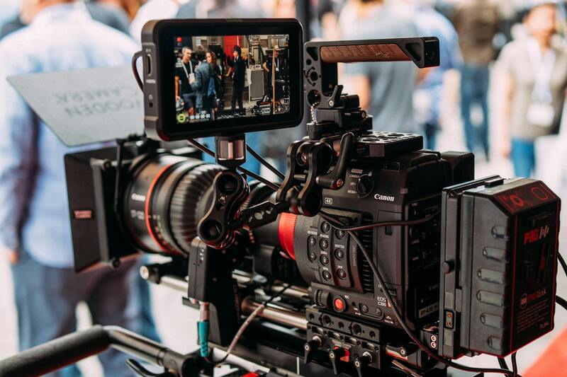
Utilizing advanced aerial equipment is essential for capturing high-quality visuals that highlight the unique characteristics of Miami properties. Professional-grade drones equipped with high-resolution cameras are commonly employed to produce sharp, vibrant images and smooth video footage. These drones often feature stabilization systems that ensure steady shots, even in windy Miami conditions, providing clarity and cinematic quality that stand out in listings.
In addition to drones, helicopters are sometimes used for larger estates or properties with expansive grounds, offering a broader perspective. Both platforms enable comprehensive coverage of a property’s exterior, surrounding landscape, and proximity to key infrastructure. In Miami's vibrant neighborhoods, these technologies allow for dynamic showcases of waterfront views, architectural details, and neighborhood amenities.
Key technological features include GPS waypoint navigation to enable precise orbit shots and automated flight paths that capture multiple angles effortlessly. High-definition cameras with adjustable lenses allow for fine detail and optimal framing, showcasing the property’s architectural nuances and surrounding scenery.
Furthermore, advancements in battery life and transmission systems ensure prolonged shooting sessions with minimal interruption, capturing extensive footage efficiently. For post-production, editing software plays a vital role in enhancing colors, stabilizing footage, and creating compelling visual stories tailored to target audiences.
The integration of thermal imaging and hyper-realistic HDR (High Dynamic Range) capabilities adds further depth and clarity to imagery, especially useful for showcasing properties with intricate architectural features or waterfront views. As drone regulations in Miami become more defined, professional operators continuously refine their techniques to maximize safety and quality, turning aerial imagery into a strategic asset for real estate marketing.
Technical Features Enhancing Aerial Real Estate Content
Legal and Safety Considerations for Aerial Shooting in Miami
Executing aerial real estate photography in Miami requires adherence to established protocols that prioritize safety, privacy, and operational standards. Professional drone operators utilize comprehensive planning tools to assess airspace restrictions, ensuring flight paths are compliant with municipal and federal guidelines. Prior to any shooting session, a detailed risk assessment is conducted to evaluate potential hazards such as nearby structures, power lines, and busy air routes, enabling the team to develop effective mitigation strategies.
Operational safety is paramount, involving meticulous pre-flight checks of all equipment, including batteries, sensors, and navigation systems. Operators also implement strict procedures for maintaining line-of-sight, avoiding restricted zones, and respecting no-fly zones designated around sensitive infrastructures or private properties. These practices help prevent accidents and protect all parties involved in the process.
Respecting individuals' privacy rights is another integral aspect of aerial real estate photography, especially in residential areas. It involves establishing clear boundaries about capturing footage, ensuring that aerial views do not infringe on personal privacy or disturb residents. Many professional teams employ techniques such as altitude regulation, directional angles, and selective framing to capture pristine property visuals while maintaining discretion.

Additionally, comprehensive training and certification for drone operators bolster safety standards and operational efficiency. Certified pilots are skilled in maneuvering complex equipment under various weather conditions, which is vital in Miami's diverse climate. Continual education ensures that operators stay updated on the latest regulations, technological advancements, and best practices, reinforcing their commitment to responsible aerial photography.
In technical terms, adhering to no-fly zones, airspace classifications, and altitude limitations prevents unauthorized activities and aligns with authorized air traffic flow. Strict operational procedures, coupled with well-maintained equipment, significantly reduce the risk of equipment failure or safety incidents during shooting. This disciplined approach enables producing high-quality aerial content safely and reliably, ultimately translating into more effective marketing for Miami real estate.
Understanding Aerial Real Estate Photography
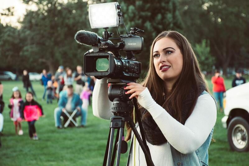
Aerial real estate photography involves capturing images and videos from elevated perspectives using aircraft, drones, or other aerial platforms. This specialized technique provides potential buyers with a comprehensive view of property layouts, surroundings, and nearby amenities, which traditional ground-level photography cannot achieve. The use of high-resolution cameras mounted on stable aerial platforms ensures detailed and vibrant visuals that highlight the unique features of each property. Proper planning and execution are essential for capturing consistent, attractive visuals that can elevate a listing’s appeal.
In Miami, breathtaking aerial shots are particularly valuable due to the city's scenic waterfronts, lush landscapes, and vibrant neighborhoods. These visuals help differentiate listings in a competitive market, allowing real estate agents to showcase properties in their best light. Precise maneuvering and framing are key, emphasizing the property’s position within its environment, neighboring structures, and scenic views. By integrating aerial images into marketing campaigns, real estate professionals can foster increased engagement and attract a broader audience.
Aerial photography also enables capturing the scale and context of larger properties, estates, or commercial spaces. For instance, an expansive Miami estate can be presented in its entirety, underpinning its exclusivity and grandeur. Furthermore, aerial perspectives can effectively demonstrate outdoor amenities such as swimming pools, gardens, and outdoor entertaining areas—elements that significantly enhance a property’s desirability.
Another vital aspect is understanding the technical constraints related to aerial photography. This includes selecting optimal flight altitudes, angles, and lighting conditions to maximize visual impact while maintaining safety. Skilled operators utilize advanced flight planning tools and techniques to achieve consistent results, even in complex environments. They also consider property-specific factors such as proximity to busy airspace, trees, and other obstructions.
Understanding Aerial Real Estate Photography
Aerial real estate photography employs the use of specialized airborne imaging equipment to capture expansive and detailed views of properties from above. This technique enhances traditional ground-level photography by providing potential buyers and investors with a comprehensive visual context that includes surrounding landscapes, neighboring structures, and overall property layout. Employing drones, helicopters, or fixed-wing aircraft equipped with high-resolution cameras enables real estate professionals to showcase properties in a manner that emphasizes scale, location advantages, and aesthetic appeal. Proper execution involves meticulous planning, including selecting appropriate flight paths, altitudes, and camera angles to highlight the property's most compelling features without distortion or loss of detail. This visual strategy is particularly effective for large estates, waterfront properties, or developments where context and surroundings significantly influence buyer perception.

Techniques and Best Practices in Aerial Photography
Effective aerial real estate photography hinges on several technical best practices. Flight paths should be carefully programmed to minimize shadows and capture optimal lighting conditions, typically during early morning or late afternoon hours. Camera settings are adjusted for clarity and color accuracy, often utilizing stabilization features to ensure crisp, steady images. Advanced imaging techniques, such as HDR (High Dynamic Range), help in capturing a broader spectrum of light, ensuring details are visible in both shadows and highlights. Additionally, employing 3D mapping and panoramic stitching software can create immersive virtual tours and comprehensive site layouts, further enhancing marketing materials. Operators must have a thorough understanding of aerial laws, safety protocols, and operational expertise to achieve high-quality outcomes consistently. Regular equipment maintenance and calibration are essential to produce professional visuals that match the high standards demanded in Miami’s competitive real estate environment.
Importance of Quality Content in Aerial Marketing
In the realm of aerial real estate marketing, the quality of visuals directly correlates to the property's perceived value. Clear, stunning images and videos can significantly increase online engagement and conversion rates. High-definition footage, combined with well-composed shots that communicate the property's scale and relationship to its surroundings, persuades prospective buyers to consider a property seriously. Moreover, professionally produced aerial content enhances branding consistency across digital platforms, increasing trustworthiness and authority within the local market. As the demand for striking visual content grows, investing in high-caliber aerial footage becomes a key differentiator. Real estate agencies in Miami increasingly recognize that sophisticated aerial visuals are not just supplementary but integral to a comprehensive marketing strategy, enabling properties to stand out amid competitive listings.
Incorporating Aerial Photography into Marketing Campaigns
Strategically integrating aerial visuals enhances various marketing initiatives. For online listings, aerial images and videos provide an immediate sense of scale and property context, attracting more views and inquiries. Virtual tours enriched with drone footage give viewers an engaging experience, allowing them to explore virtual environments more interactively. For social media campaigns, short aerial clips or time-lapse videos generate attention and increase shares, broadening the reach to potential buyers and investors. Additionally, aerial content can be used in printed brochures and digital ads to communicate luxury and exclusivity. Ensuring that these materials are optimized for each platform maximizes their impact, turning high-quality visuals into effective tools that accelerate the sales process and elevate the property's prestige.
Legal and Safety Considerations for Aerial Shooting in Miami
Executing aerial real estate photography in Miami requires adherence to established protocols that ensure safe operation and responsible use of aerial equipment. Engaging in drone flights should always follow operational guidelines designed to protect both the equipment operators and other airspace users. Proper planning involves assessing local airspace restrictions, understanding no-fly zones, and obtaining necessary permissions for flights near sensitive locations, such as airports, government buildings, or densely populated areas.
Operators must conduct pre-flight risk assessments to identify potential hazards, including adverse weather conditions, obstacles like tall structures, and local wildlife activity. These evaluations are essential in planning safe flight paths and altitudes that minimize disturbance and maximize the quality of captured footage. Additionally, flight paths should be carefully mapped out to maintain clear line-of-sight with the drone, ensuring full control during operation and reducing the likelihood of accidents.
It is vital to respect privacy boundaries by avoiding intrusive or invasive filming practices that could compromise the privacy of residents or trespass on private property. Properly calibrated drones equipped with GPS and collision avoidance systems significantly reduce the risk of accidents, but human vigilance remains paramount. Routine equipment maintenance and operator training ensure that all flight operations meet high safety standards, preventing malfunctions or operator errors that could lead to incidents.
Lastly, staying informed about local regulations and industry best practices is crucial, as these may regularly evolve alongside technological advancements and changing airspace policies. Working with experienced aerial service providers who stay up-to-date with municipal regulations can facilitate seamless, compliant, and safe aerial filming experiences in Miami’s dynamic environment.
Understanding Aerial Real Estate Photography
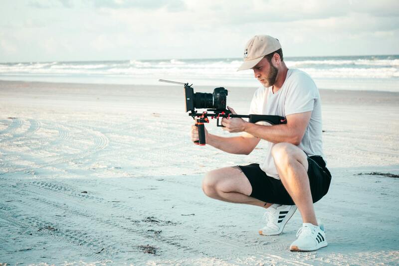
Aerial real estate photography is an advanced imaging technique that captures property and surrounding landscapes from elevated perspectives, utilizing unmanned aerial systems (UAS) or drones equipped with high-resolution cameras. This approach provides a comprehensive view of properties, showcasing features that are often difficult to capture through traditional ground-level photography. In Miami, where architectural diversity and coastal views are prominent, aerial photography serves as a vital tool to highlight unique property attributes, such as expansive acreage, waterfront locations, lush landscaping, or impressive estate layouts. Professional operators employ precise flight planning and stabilization technologies to ensure sharp, well-composed images and videos that accentuate the property's size, scale, and contextual surroundings. The strategic use of aerial perspectives enhances visual storytelling, offering potential buyers a compelling overview that fosters emotional connection and informed decision-making.
Benefits of Using Aerial Footage in Real Estate Listings
The integration of aerial footage into real estate marketing campaigns offers numerous advantages. First, it significantly increases audience engagement by presenting dynamic visual content that stands out on digital platforms. Aerial videos help illustrate the property's scale, layout, and proximity to key amenities like beaches, parks, or urban centers—particularly relevant in Miami's vibrant neighborhoods. Additionally, aerial imagery highlights boundary lines, landscape features, and architectural details that ground-level shots might overlook. This comprehensive visual narrative can lead to faster sales, higher offers, and increased property visibility. Furthermore, premium aerial visuals elevate the professionalism of listings, instilling buyer confidence and portraying the property as a high-value, desirable asset. When effectively incorporated into online listings, virtual tours, and marketing materials, aerial footage creates a compelling story that resonates with prospective investors and homebuyers alike.
Popular Aerial Equipment and Technology for Real Estate in Miami
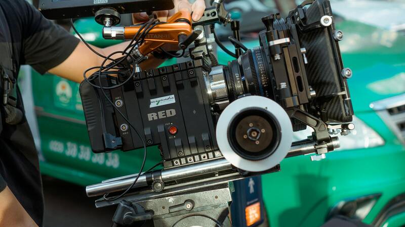
Successful aerial real estate showcasing hinges on leveraging sophisticated equipment designed for precision and safety. In Miami, where diverse landscapes and complex urban environments are common, professionals often utilize drones with high-resolution 4K cameras and stabilization systems to ensure clarity and cinematic quality. Multi-rotor drones are prevalent for their maneuverability and ability to capture detailed images from multiple angles. Advanced flight controllers with GPS capabilities enable precise positioning and repeated shots for consistency across projects. Additionally, incorporating gimbals ensures smooth footage, while multispectral sensors can provide specialized views for highlighting landscape health or landscaping features. For ground-to-air complementarity, professional-grade camera rigs and panoramic lenses expand creative options. Adopting the latest mapping software and digital editing tools further enhances post-production quality, delivering polished visuals tailored to each Miami property’s unique appeal.
Legal and Safety Considerations for Aerial Shooting in Miami
Executing aerial real estate shoots within Miami demands meticulous adherence to established procedures designed to promote safety and respect for privacy. Operators must conduct pre-flight assessments that account for local airspace restrictions, nearby structures, and environmental conditions. Utilizing state-of-the-art collision avoidance systems and GPS stabilization reduces risks associated with flight deviations or equipment malfunction. Maintaining clear communication with property owners and local authorities helps coordinate flight times to minimize disruptions. Additionally, flights should be conducted at controlled altitudes, avoiding sensitive zones such as airports, heliports, or military areas. Prioritize on-site safety by establishing perimeter boundaries and ensuring all crew members are aware of emergency protocols. Regular maintenance and calibration of equipment safeguard operational integrity, while ongoing training keeps operators proficient in handling complex urban environments. Staying abreast of evolving regulations, airspace policies, and technological updates ensures that aerial shoots proceed smoothly and compliantly, reflecting professional standards and a commitment to safety.
Effective Aerial Marketing Strategies for Miami Real Estate
To maximize the impact of aerial visuals, Miami real estate professionals should integrate aerial content into a comprehensive marketing mix. High-quality videos and images should be optimized for various platforms—including social media, property websites, and virtual tour applications—to reach diverse audiences effectively. Emphasizing drone-captured features that showcase lifestyle benefits, such as waterfront access, skyline views, or sprawling outdoor spaces, appeals to target demographics including luxury buyers and investors. Strategic use of aerial content in open house events or virtual walkthroughs can create immersive experiences, elevating engagement and interest. Collaborations with local marketing agencies experienced in real estate branding enhance content distribution, ensuring maximum exposure. Incorporating compelling narratives with aerial visuals—highlighting property uniqueness or neighborhood amenities—can significantly boost lead generation and conversion rates. It’s essential to maintain consistency in visual quality and branding standards across all marketing channels, reinforcing the property’s premium positioning in Miami’s competitive market landscape.
Case Studies of Successful Aerial Real Estate Campaigns in Miami
Successful aerial campaigns in Miami demonstrate the transformative effect of high-caliber visuals on property marketing outcomes. For instance, luxury waterfront estates have leveraged drone footage to showcase expansive pools, private docks, and panoramic ocean views—transforming listings into captivating visual stories. In one case, a high-rise condominium project utilized aerial videos to emphasize proximity to Miami’s iconic skyline and vibrant neighborhoods, significantly shortening the sales cycle. Another example features a gated community, where drone photography revealed extensive landscaping, recreational facilities, and nearby amenities, attracting discerning buyers seeking exclusivity. These campaigns typically combine carefully planned shoot schedules, professional editing, and targeted digital distribution, resulting in measurable increases in inquiries, virtual viewings, and ultimately, sales. Such success stories underscore the importance of quality aerial content tailored to the specific lifestyle and architectural features unique to Miami, reinforcing its reputation as a hub for innovative real estate marketing.
Legal and Safety Considerations for Aerial Shooting in Miami
When engaging in aerial real estate photography within Miami, it's crucial to adhere to established protocols that prioritize safety and drone operation standards. Permits from local authorities may be required for certain flight zones, especially when operating near airports, helipads, or densely populated areas. Ensuring that drone operators hold current certifications and are well-versed in FAA regulations helps mitigate unforeseen issues during shoots.
Flying in Miami's diverse environment involves understanding no-fly zones, sensitive locations, and temporary restrictions that could be in place due to events or construction. Conducting thorough pre-flight planning with local authorities and utilizing updated airspace maps minimizes risks and streamlines the process. It's essential to map out your flight path meticulously, maintain safe altitudes, and avoid infringing on private property without explicit permission.
Operational safety extends beyond airspace regulations. Drones must be maintained meticulously—checking battery levels, propeller integrity, and signaling equipment before each shoot. Having a clear communication plan with ground personnel ensures coordination, especially during complex shots or crowded neighborhoods. Additionally, pre-visualizing the shoot area helps anticipate potential hazards such as power lines, tall trees, or moving vehicles, preventing accidents or damage during flight.
Furthermore, preparing a safety risk assessment that covers weather conditions—like thunderstorms, high winds, or heavy rain—is vital since Miami's climate can impact drone flight stability. Post-flight protocols should include reviewing footage immediately to confirm comprehensive coverage and image quality, minimizing the need for retakes that could extend shoot time and costs.
Effective Aerial Marketing Strategies for Miami Real Estate
Successful aerial marketing in Miami involves more than capturing stunning visuals; it requires integrating drone footage into broader digital campaigns to maximize reach and engagement. Incorporating aerial videos and photos into virtual tours, social media posts, and property websites enhances the immersive experience, drawing potential buyers' interest through high-quality visual storytelling.
One approach is to tailor content to highlight Miami’s unique lifestyle and architectural styles—be it beachfront estates, luxury condos, or gated communities. Effective strategies include producing thematic sequences that showcase sunrise or sunset vistas, drone flybys emphasizing property orientation, and panoramic views of nearby attractions. This not only accentuates the property’s features but also contextualizes living in Miami, appealing to the aspirational nature of buyers.
Targeted digital advertising campaigns that utilize geofenced locations and demographic data can direct aerial content specifically toward qualified audiences. Integrating drone footage into virtual open houses and interactive listings can significantly increase engagement metrics, prompting more inquiries and virtual walkthroughs. Collaborating with local real estate brokers to create branded multimedia packages further amplifies the property's appeal in a competitive market.
In addition, leveraging analytics tools to evaluate viewer engagement and campaign performance provides insights into which visuals resonate most with prospective buyers. Adjustments based on this data—such as highlighting specific property features or optimizing viewing times—can continuously improve marketing effectiveness. Regularly updating content with new footage or seasonal variations keeps listings fresh and competitive in Miami’s vibrant real estate landscape.